Ten years ago, on August 21 2000, I hefted one of the heaviest packs I’ve ever carried onto my shoulders and headed into Wyoming’s Wind River range on a week-long backpacking trip with my friend Damon. Damon is one of my most frequent outdoor adventure partners, and over the preceding years we had done quite a few backpacking trips together, most frequently in California’s Sierra Nevada range. For this trip we had our sights set on Gannett Peak, Wyoming’s highest peak (13,804’) and probably the most challenging state high point in the Lower 48.
There’s more than one approach to Gannett Peak, but none that are short. Despite being the highest peak in the state, Gannett isn’t visible from many places in civilization. That remoteness is one of the factors that increases the difficulty rating of Gannett’s summit. Our route followed the Glacier Trail on the east side of the Wind River range for 20 miles up Torrey and Dinwoody Creeks, to a point where we planned a multi-day base camp. From the base camp we’d be able to complete the summit ascent of Gannett in a single long day, but we gave ourselves a 4-day window in case weather conditions became an issue. We’d use the other 3 days to peak-scramble and explore some of the surrounding terrain.

The first day of our 2-day approach involved a strenuous 10-mile, 3300’ vertical climb up the Torrey Creek drainage to a beautiful campsite near Star Lake. Discouragingly, we knew that we’d give back most of that elevation the next day on a long switch-backed descent to Dinwoody Creek. But Dinwoody Glacier is the source of the creek, and that glacier is one of the five that surrounds Gannett Peak, so the creek signified that we were getting closer to our objective.

Finally, on the afternoon of the second day and more than 17 miles into the trip, we got our first view of the peak. The view of Gannett’s large summit snowcap was inspiring but also a bit intimidating.

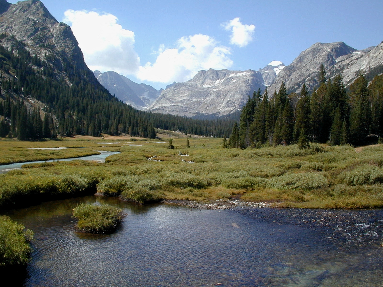
Continuing up Dinwoody Creek, we passed through the beautiful sub-alpine Floyd Wilson Meadows. Moose are common in this area, and we saw several bulls and cows as we crossed the meadows and climbed to a point just below treeline.

In addition to the standard backpacking gear and eight days of food provisions, we also carried in crampons, ice axe, rope and a small climbing rack. That extra mountaineering gear had brought the weight of our packs up to around 80 pounds. We set up our basecamp at around 10,500’ in the last set of tall trees, still more than three thousand vertical feet below the summit of Gannett, and planned to make our summit attempt in the morning.


The following morning dawned clear and cold, and we set out by 6:45. Our route involved crossing seemingly endless talus fields to access Gooseneck Glacier, and then ascending the glacier and snowfields to the summit ridge.

Mountaineering crampons and an ice axe are all that is needed for most of that ascent, however there is a crux pitch up 45-degree snow and ice in Gooseneck Gully where rope and a belay are advisable. Above the gully there is still quite a bit of climbing to do, mostly over third and fourth class rock. Once we attained the final summit ridge, views of the Tetons open up to the northwest. In the final quarter-mile approach to the summit, the summit ridge narrows considerably, with the sheer drop-off of Gannett’s west face on the immediate left and steep snowfields on the right. Those snowfields form the summit snowcap we had seen the day before on our approach.

I should mention that Damon has always had difficulty with exposure and altitude. Although some rock climbing experience over the past year had given him the confidence to overcome some of his fear of heights, we both knew that this climb could turn out to be a bigger challenge for him than me. But we also knew from other backpacking trips we had taken together that we were well-suited as partners for this trip, so we relied on good physical conditioning (we were both training for fall marathons) and my relative comfort with exposure to pull us through. This proved to be a good strategy, with me taking the lead up the handful of steeper exposed sections and providing rope and a belay for Damon when needed.


Damon tagged the summit first, having gotten ahead of me the last time I had stopped to pack our rope. A few minutes later I showed up and we signed the register. About 300 people had climbed the peak that year. With good weather in our favor, we lingered on the summit for a bit, but eventually started down, anxious to get some of the more difficult descent segments behind us. By the time we reached our base camp, we had been gone almost exactly 12 hours.

Back in the relative comfort of our base camp, we mixed up a batch of celebratory margaritas, considered a hydration necessity on extended backpacking trips, and kicked back.

The following day Damon opted to rest and recover, but I decided to do some exploration of the terrain around our basecamp, so I headed out on a half-day, third class solo climb of nearby West Sentinel Peak. The ridgeline and summit gave an interesting straight-on view of Gannett and much of our route from the day before. At the summit, I signed the register placed by the Chicago Mountaineering Club thirty years earlier. Other than me, just a handful of climbers had signed the register that year, so I wouldn’t be surprised if it’s another thirty years before the register needs to be replaced.

Having napped and snacked the afternoon away, Damon was ready for adventure the next day. We decided on a route across Dinwoody Glacier and then up steep talus fields to Dinwoody Pass and Dinwoody Peak. The pass and peak lie directly on the Continental Divide just south of Gannett Peak. The pass is also a portal for climbers ascending Gannett from the western approach. Although we roped up for the glacier, the climbing was relatively easy. Above the glacier, steep talus led to the pass and even steeper talus to the summit of Dinwoody Peak, elevation 13,500’. The summit register had been placed in 1961, and we were the fourth or fifth party that year to sign.

Dinwoody Peak is the western-most (looker’s right) of a cluster of three soaring pinnacles above Dinwoody Glacier. The view from the summit inspired us to consider a triple traverse of the three peaks: Dinwoody, Doublet and Warren… some other time. That traverse involves a rappel from the summit of Dinwoody, ascents of Doublet and Warren, and then an exciting descent (Damon used the word “horrifying”) of the elevator shaft ice couloir leading back to Dinwoody Glacier below. That route is clearly visible in the photo above, taken from the talus fields below Dinwoody Glacier.

On the final day before our exit hike, we opted for a hike / climb up Philsmith Peak, a minor 12,700’ summit to the northeast of our camp. Although the climb itself was over easy low-angle snowfields, the summit provided dramatic views of Klondike Lake 1500 vertical feet directly below.

We began our exit hike the next day, retracing our approach route. At the final viewpoint before Gannett disappeared behind us, we couldn’t help but reflect on the area’s wildness, remoteness and beauty. It’s hard to imagine a spot in the lower 48 with so many significant glaciers and spectacular peaks packed into so small an area. There aren’t many trails or easy hikes, but the rewards are solitude, unrivaled alpine scenery and plenty of challenge.
Harvey44
ReplyDeleteAug 25, 2010; 11:30pm
A few dumb questions from a high altitude novice:
• What is a "crux pitch?" Can you explain the "classes" of rock?
• The biggest pack I've carried (skied with) was 60 pounds and to me that felt like the absolute limit. 80 lbs over that distance and elevation gain is a major accomplishment. How much did you weigh at the time? What was the weight of your summit pack?
• The whole concept of navigating glacier crevasses is intimidating. In summer are crevasses hidden? How much danger did you sense from that aspect of climb?
The feeling I get from reading this account is second only to actually challenging my own limits. It's my favorite kind of reading.
Sure doesn't seem like a fading memory is an issue. Still it has to be a great feeling to get it down. Vivid story telling and images. An inspiring, world class TR. Thanks for bringing this level of documentary to Harvey Road.
Highpeaksdrifter
Aug 26, 2010; 07:52am
Spectacular pictures and TR.
Adk Jeff
Aug 26, 2010; 12:12pm
Harv, the standard reference is “Mountaineering: Freedom of the Hills” published by Seattle-based The Mountaineers. It makes excellent and interesting reading even if you have no intention of ever putting those skills and knowledge into practice. Some brief answers to your questions:
In climbing and mountaineering, a crux is the most difficult segment of the climb. There is a continuum of difficulty grades in climbing, from Class 1 to Class 5:
-Class 1 is simple walking or hiking.
-Class 2 is scrambling, involving the use of hands. There is little danger of injury from a fall.
-Class 3 is scrambling but with exposure. A fall could result in serious injury or even death. A rope may be used depending on the climber’s comfort level.
-Class 4 is similar to Class 3 but with more difficult climbing. A rope is advised and a fall could prove fatal.
-Class 5 is technical climbing with rope, harness, belay technique and hardware for protection. Class 5 is further broken into decimal grades from 5.1 (easy climbing) up to around 5.15. The grading system originally went from 5.1 to 5.9, but as equipment and technique improved the more difficult 5.10, 5.11, 5.12 etc. grades were added.
As for the glacier travel, the crevasses were exposed and easy to see and avoid. Although we roped up for glacier travel and used crampons and mountaineering ax, for the most part the glacier travel was more like being on a snowfield.
80 pounds is a huge pack. I can honestly say that the second day of the approach hike beat me up pretty badly, despite my conditioning level being the highest it’s ever been. I was around 150 lbs then, closer to 160 now. Originally, we had not planned a 5-night base camp. Rather, the “plan” (or maybe it was just an “option,” I don’t recall) was to backpack up and over Dinwoody Pass into the basin on the other side and camp there for a night or two. The torture on the approach hike was the deciding factor in scrapping that option and establishing the base camp instead. That turned out to be a great decision, and didn’t at all limit our ability to explore the area. Our summit packs probably came in at 20 lbs or so.
One thing I have to add: I have a TR/journal that Damon wrote up immediately following the trip. His report was immensely useful in recalling the details for this TR.
Jamesdeluxe
ReplyDeleteAug 26, 2010; 03:31pm
That's a brutal pack weight. You're a total badass.
Did you scan in those photos or did affordable digital cameras already exist ten years ago?
JasonWx
Aug 26, 2010; 03:43pm
What a fantastic looking trip.. A couple of years ago I almost pulled the trigger on a Grand Teton climb. That would be a easy hike compared to what you did.
80lb pack is totally insane, my rock climbing pack weighs around 35lb which I find heavy as hell..
Adk Jeff
Aug 26, 2010; 09:40pm
James, those pics were taken on a digital camera.
Badass... nah. Damon gave me a great quote from Heinrich Harrer’s “The White Spider”, about the North Face of the Eiger and its climbing history: “But then isn’t the ability to hump heavy loads a requisite for every successful major climb?” Indeed!
If anyone was badass, it was Damon, who on the second approach day motored to our basecamp site with me trailing 15 minutes behind. I had gotten burnt on the morning descent to Dinwoody Creek and never recovered for the rest of the day. Truth is, we each had points on the trip where we were stronger than the other: that's the key to a successful mountaineering partnership.
Adk Keith
Aug 27, 2010; 11:49am
The Winds are an amazing area. Did a trip in there 35 years ago (wow is that possible?) when I was 17, into the Titcomb Lakes basin. Feasted on cutthoat trout and watched dipper birds walking along the bottom of streams hunting. Glissading snowfields frosted with pink algae in mid August.
Thanks for this report that brings it all back like yesterday.
Adk Jeff
Aug 27, 2010; 01:28pm
Keith, Titcomb Lakes Basin is the basin that I referred to in my TR & comments as being directly on the other side of Dinwoody Pass. As mentioned, we had considered dropping over the pass and camping in Titcomb Basin for a night or two, but ended up staying put with our base camp and doing exploratory day hikes from there. We peered down into Titcomb Basin from on top of Dinwoody Peak and it sure looked like a great destination.
I also mentioned in the TR that Dinwoody Pass is a portal for climbers ascending Gannett Peak from the western approach. In that scenario, a climber would have a base camp in Titcomb Basin, and then have a VERY long summit day that involved climbing Dinwoody Pass from Titcomb Basin, descending to the Dinwoody and Gooseneck Glaciers and then ascending Gannett via the standard Gooseneck route that Damon and I climbed. Even moving fast, that's probably more like a 16+ hour day versus the 12 hour round trip that we had on summit day. I assume you backpacked into Titcomb Basin from the west side of the Wind River range? That's a 2-day approach as I recall. Do any peak-bagging while you were in there?
Adk Keith
Aug 30, 2010; 10:23am
Yes, as I recall, we came in from Pinedale. We hiked 9 miles into lower Titcomb basin to a horse camp where they were drinking beer, grilling steaks and playing frisbee. My partner said to me "we can stay here or go an additional 5 miles up the basin to beyond where horses are allowed". No brainer, hiked the additional 5 miles. We stayed in there for two nights and on the 3rd day in the afternoon we realized we had no more food and started the forced march 14 miles out, arriving at the trail head at 10 PM. I remember wanting to just lie down next to the trail to sleep. Ended up with 50 cent size blisters on both heels that were still evident a month after getting home. Ah to be 17 again. :)
We climbed a couple of smaller peaks around the basin but had no equipment to do anything very serious. As it happened I was with Al Breisch who used to be mentioned in the old ADK Rock Climbing guide as doing a few first ascents with others in the "60's with a crew from Penn State outing club.
Stunningly beautiful area.
Adk Jeff
ReplyDeleteSep 11, 2010; 10:02pm
Keith, pic from Upper Titcomb Basin (not my photo. Dinwoody Pass is visible as the low saddle in the far right.
Adk Keith
Sep 13, 2010; 08:29am
I definitely need to get my slides scanned, especially the ones from that trip.
Thanks Jeff
Hi, I love the picture of the snowcap peak and stream. I would love to include the image as a collage for a poem I wrote entitled thawed heart. Would you permit me to use this wonderful picture?
ReplyDeleteGannett Peak's summit snowcap above Floyd Wilson Meadows
ReplyDeleteThat picture is a beauty. Would love to use it in my collage. I am seeking your permission to use it.
Yes, there's no problem using those photos. Thanks for asking.
Delete