This past Sunday Beth and I did an 8-mile trail run over Cat and Thomas Mountains, ownership of which was recently transferred from the Lake George Land Conservancy to New York State.
Although I’m constantly greeted with skepticism from runners and hikers alike regarding the suitability of rugged trails like Cat and Thomas for running, the combination of roots, rocks and vertical pays dividends in the form of balance, agility and strength. At least that’s what I’m hoping for when I run in the Moreau Lake 15K trail run this weekend and the Whiteface Uphill Footrace the next weekend.
But I had more than just my own fitness goals in mind when we set out Sunday afternoon. For one thing, we had a relatively narrow (2 to 3 hours) window of opportunity for leaving the kids with family members. It’s hard to beat a trail run when it comes to covering a bunch of ground quickly. On top of that, I’ve hiked Cat before and been up Thomas more times than I can remember, but somehow never did the loop over the two peaks as a single trip. And lastly, the persistently muggy, showery weather over Labor Day weekend made conditions less than ideal for hiking (though you wouldn’t know it from the full parking lot at the trailhead), but fine for a trail run, where it’s more about the challenge of the terrain than the view from the summit.
A beautiful stretch of trail on top of Thomas Mountain
View of Cat Mountain from Thomas. Our route follows the ridge on the right.
We ran the loop counter-clockwise, going over Thomas first, then following the blue-marked Ridge Trail to Cat, and returning on the yellow-marked jeep trail. This gives the benefit of knocking off the longest, steepest uphill segment in the first mile and a half. The next two and a half miles, from Thomas over to Cat, were probably the most overall challenging segment of the loop, with lots of ups and downs, rocks and roots, and a significant climb to Cat’s summit. There are some interesting views along the way, including an overlook with views to the west about a half mile below Cat’s summit. But the real reward comes at the top of Cat, where 180-degree views extend from Tongue Mountain and Lake George’s narrows all the way through the Lake’s southern basin and to the west. Even on cloudy day, the view is impressive.
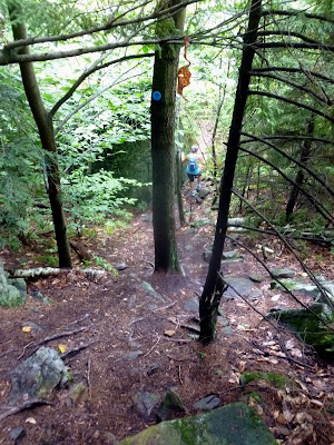
A steep drop below Thomas Mountain's summit
Looking back at the Thomas Mountain cabin en route to Cat
The remaining three and a half miles from Cat’s summit back to the trailhead at first seem easy, at least compared to the technical terrain already covered. After all, it’s a jeep road. But miles add up and the route seems longer than it should be. That’s the challenge in a long run: you want it to be over, but you have to just keep going.
Even on a cloudy day the Cat Mountain view is beautiful: Black Mountain, Tongue Mountain and Lake George. And this is just the eastern third of the view!
We finished the loop in 2:40, twenty minutes inside of the three hour window we had given ourselves and feeling not too beaten up. We’ll see in a week or two if I collect on those dividends.


No comments:
Post a Comment