Crane Mountain is one of those hikes that’s on everybody’s list of the best hikes in the Adirondacks. I’ve got at least a half dozen guidebooks that include Crane, but my favorite description of Crane’s trails is in my 25+ year old Discover the Southeastern Adirondacks guidebook by Barbara McMartin, aka “the Rand McNally of the Adirondacks.” McMartin enthusiastically dubs Crane the “Super Mountain” of the southern Adirondacks for its variety of trails and bushwhacks, its alpine pond and its expansive summit views.
Yup, the trail's that steep
I’ve hiked Crane a number of times over the years, but this is the first time I’ve done it with our kids. Crane fits in well with my criteria for a good family hike: its 4.5 mile round trip and 1500 vertical feet of climbing are well within our kids’ ability (they are ages 6 and 10), plus there’s the added interest of the pond half way up the mountain. And its location in the southern Adirondacks makes the drive to the trailhead relatively short.
One nice thing about all those rocks: no mud!
Nice open ledges partway up to the pond
We were lucky to hike Crane on the kind of day when it would have been borderline criminal not to hike. The air was crisp and clear, the trees were clad in an almost fluorescent yellow-green of late spring, and the woods still sheltered a variety of blooming wildflowers. A light breeze held most of the bugs at bay.
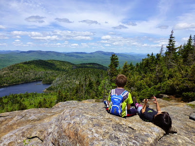
The ledges are a great spot for a snack break
Rolling hills and mountains of the southern Adks
We climbed the eastern trail to the pond from the trailhead on Ski Hi Road (there’s also a western trail to the pond). Since the trail forms a loop between the pond and the summit (here's a map), it’s possible to visit either the pond first or the summit first: we chose the pond in order to break up the climbing.
First view of Crane Pond from the trail
Part way around the pond on the way to the western summit trail
No matter how you slice it, it’s a stiff climb to the pond, 900 feet of elevation gain in less than a mile. This could be an issue for some kids (some adults too), but our kids like scrambling over rocks, and since the climb came early in the hike they had lots of energy.
Western summit ledges, about .2 miles below Crane's summit. Gore is the highest peak on the horizon, just to the right of the pond
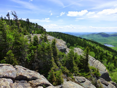
Looking east across more open ledges below Crane's summit
Summit view, Garnet Lake is in the distance
There’s another 600 vertical feet of climbing between the pond and the summit. The trail ascends the western end of the summit ridge, and there are excellent views from several lookouts before you even get to the summit. The best views (even better than the summit views in my opinion) are from the western-most viewpoint, about a quarter mile shy of the actual summit. Here, Crane Mountain Pond sparkles in the sun hundreds of feet below with a backdrop of peaks that includes Gore, Snowy, Mount Blue, Hadley Mountain and the High Peaks.
Starting the descent of the eastern summit trail
The first ladder is just below the summit
The ladder is steep and high
The summit views are almost as good, although Crane Mountain Pond isn’t visible. Crane Mountain once had a fire tower on its summit, now only the anchor bolts remain. Uncharacteristically, the kids seemed content to hang out on the summit for a while, eating lunch and taking in the view.
Some of our finds along the hike:
Bunchberry
Clintonia
Rose twisted stalk (I only knew this one from following this blog)
Trillium
Witch hobble
Newt (red eft actually)
Froggy
Continuing on the loop trail, the route drops steeply down the eastern end of the summit ridge, using an impressively tall ladder in the steepest section. Since it's a pretty direct shot down the mountain, it seemed like we were back at the trailhead in no time. Including our stops at the pond and the summit we took a little over 4 hours on the round trip.
With a warm-up hike under our belts now and school ending in just a few more weeks, hopefully some more family hikes lie just around the corner. I know I've got a few hikes on my hit list for the summer.


Great hike. I would add that for first-timers the trailhead can be challenging to find. And you need more ways for people to comment without a URL.
ReplyDeleteYou're right, directions to the trailhead can be tricky to follow, especially since the trailhead can be approached from more than one direction. Best bet is to match up the guidebook directions with your map to be sure of where you're heading. One thing that may be helpful, the AMC's Discover the Adirondack guidebook includes gps coordinates for the trailhead. Maybe the newer editions of the ADK's guidebooks and the Discover series (the Barbara McMartin guidebooks) include gps coords now too - mine are about 20 years old.
DeleteAs for the commenting options, this blog is published using Google's Blogger software, so the options are limited to what Google provides. But you can always comment without an URL anonymously and include your name or other identifier at the end of your comment.
Thanks for reading and commenting!