
Although the hike is short (2 miles each way), there are some sustained moderately steep pitches as the trail gains almost 700 vertical feet. Like many Adirondack trails, parts are rocky, rooty and eroded.

Part of the "charm" of hiking in the Adirondacks can be conflicting trail signage. The trailhead register said 2.0 miles each way, my guidebook called it 1.7, and the math on the trail signs below comes out to 1.5. I'll go with the 2.0 measurement, but if you do the hike WITHOUT kids it may feel more like the 1.7.

We found plenty of mushrooms, fungus, small streams and even butterflies to hold the kids' interest in the lower sections.


About a half mile in, the trail passes near Chub Pond.

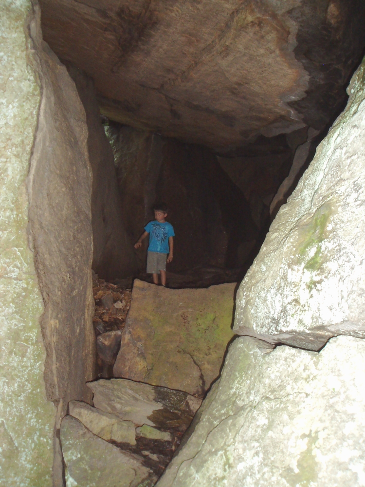
After climbing several hundred vertical feet up a shoulder of the mountain, you reach the base of the cliffs that form the mountain summit. There is a network of footpaths leading through gigantic boulders that leads to many interesting caves for exploration. The first is an opening in the back of a huge room with a 25' ceiling, formed by the overhanging cliff.


To the west, Eagle Lake is visible, as is a thin sliver of Racquette Lake. The summit rock falls away to steep cliffs, so it's an area to pay attention, especially with small kids.

On the hike back down, look for additional caves that you may have missed on the way up. Although the footing can be a bit tricky on the steeper trail section above the caves, most of the hike out is pretty easy. On the way home, we made a stop in the village of Blue Mountain Lake to check out the town beach and enjoy ice cream at the Blue Mountain Lake Boat Livery, whose enticing roadside sign pulled us in.


Blue Mountain Lake is one of those authentic Adirondack villages with no chain restaurants, motels or stores for miles. It's a charming, welcoming spot surrounded by beautiful lakes and mountains. Actually the word "village" may overstate the size of Blue Mountain Lake, but it was just right for our family on Saturday.
Jamesdeluxe
ReplyDeleteJul 18, 2010; 08:42am
Besides the big villages (Tupper Lake, Lake Placid, and Lake George -- does LG count as the ADKs?) are there chain restaurants in the Adirondacks? I mentioned in earlier threads that chains avoid the Catskills like the plague.
P.MAC
Jul 26, 2010; 10:00am
Jeff - Thanks for sharing info on this hike. We have two teens and a 5 yr old mid-life "surprise" who LOVES to hike. Still, we have to choose with some care. Had friends up at our cabin with us a few weeks back and I chose Vanderwhacker Mt so they would have a good view of the high peaks. View at the top (there is a firetower as you probably know) was great as I suspected but I ended up carrying our little one for a good part of the hike. Earned my apres hike that day!
Sounds like this one might satisfy our teens and also our little one. I'm guessing it would also be a pretty good drive from North Creek... I'll check the map. Thanks again!!
P.Mac
Adk Jeff
Jul 26, 2010; 01:02pm
PMAC, I suspect that Castle Rock would be a good fit for a family hiking with a 5yo. Drive time is maybe 40 minutes from North Creek. My recollection is that Vanderwhacker is a longer hike with more vertical than Castle Rock. If you haven't done Goodnow Mountain in Newcomb, that's a good family hike as well -- views are similar to Vanderwhacker (High Peaks from the south), but with less mileage and vertical. Also, Chimney Mountain (located near Indian Lake) is a short hike with great views and quite a few ice caves located just below the summit. The ice caves can be tricky to locate (whereas the caves at Castle Rock are obvious), but if you have Barbara McMartin's guidebook (her "Discover the Adirondacks" series) there are detailed descriptions and drawings that will allow you to locate and explore the ice caves -- make sure to bring a headlamp or flashlight.
P.MAC
ReplyDeleteJul 26, 2010; 05:31pm
Jeff - Thanks! Right now we seem to have bought into "Adirondack Trail Guides" with various authors for each area. I think the park is broken into 7 or 8 "regions." There is a book for each region and each guide (book) has a detailed map in a protective plastic cover on the back page. the older versions were published in 1980 ours are up at the cabin but I think they are the 1995 or 97 revision. I have been buying them on ebay for ten to fifteen dollars. We really like them. We keep a list of hikes and we follow them by order on the list. We will include all of your recommendations on the list.
We will prioritize and take the easiest first since I fractured my neck in three places a week ago and will be three months recovering. We probably won't even attempt an easy hike until sometime in Sept. Biggest danger is that for now, I cannot look down, neck brace doesn't allow it.Your vanderwhacker recollections were good. It was a lot of vertical and followed a trickling (i hesitate to call it a stream) drainage line that we wet and muddy about 60 percent of the time. THANKS for the reply, we will keep all of your hikes on our list. Let me know if you think of any others.
PS - we also did Kibby Pond which is just a few miles down Rt 8 from our cabin. Kind of a rolling hike but not hard and only 1.8 miles one way (I think). When we got there, there were two aluminum boats leaning against the trees at the edge of the lake which, it would seem, people were free to use. A few locals told me there was good fishing on the pond. I'm gonna bring a fishing rod next time!
Adk Jeff
Jul 27, 2010; 01:57pm
Sorry to hear about your injury, best wishes on your recovery.
Sounds like you have the guidebooks published by the Adirondack Mtn Club. They are the definitive trail guides for the region. There is one drawback to those guidebooks which is that they are limited to the "official" (i.e. marked & maintained by NYS DEC) trails. Barbara McMartin's guidebook series covers the "official" trails as well but also includes off-trail routes, bushwhacks and other explorations. Enjoy your Adirondack adventures and again best wishes for a full and speedy recovery. See you on the slopes...