With the upcoming Whiteface Mountain Uphill Footrace as my excuse for “needing” to run up a mountain, I did a quick trail run up Thomas Mountain on Sunday afternoon. Since we were already in Bolton Landing for the afternoon, the trailhead was only a few minutes’ drive away.
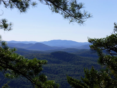
View from the blue trail overlook
Thomas Mountain might not be ideal for trail running: there are some steep sections, and the jeep road that I descended has quite a bit of loose rock. But since I only had a one-hour window for my run, convenience wins out.
More views from the blue trail overlook, looking south
The new Blue trail up Thomas makes a loop hike or run possible. Seventeen minutes after signing the trail register, I reached the cliffs overlooking the Schroon River valley. It’s amazing how nice the views are for a mere seventeen minutes of effort. It’s also amazing how quickly I can reach the overlook traveling solo: it takes the better part of an hour to reach this point hiking with the kids.
Smooth, soft trail along the Thomas Mountain ridgeline
The next half mile or so may be the nicest part of the loop. Here, the trail follows the ridgeline, winding through tall pines. Most of the climbing has already been accomplished, so it’s easy to pick up the pace. Occasional views open up through the trees as the trail approaches Thomas Mountain’s summit cliffs and cabin. From the summit proper, a 180-degree view includes Buck and Pilot Knob Mountains, most of Lake George’s southern basin, and the rolling peaks of the southern Adirondacks.
Lake George's southern basin from Thomas Mountain's summit
Descending the Thomas Mountain jeep trail, I was back to the trail register exactly one hour after signing in. That includes nearly 20 minutes of exploring around the blue trail’s overlook cliffs for additional views (didn’t find any) and snapping photos there and on top of Thomas. I covered about 3.5 miles and 800 vertical feet. Next time out I'll continue on the blue ridge trail out to Cat Mountain, making a 7-mile loop over both peaks. I didn't have quite enough time for that on Sunday (should be doable in 2 hours), but I'm not complaining. For a one hour outing, the shorter loop provided plenty of bang for the buck.
For more information on the Lake George Land Conservancy and their Cat and Thomas Mountains Preserve, click here.
For more trip reports from Cat and Thomas Mountains, click here.


No comments:
Post a Comment