Sunday November 6 was my birthday (39 again!), and while it would have been fun to ski on my birthday, that wasn’t in the cards for this year. Instead, we fit in a quick hike on a new (2014) trail that I’ve been wanting to check out. As a bonus, the cold front that had swept through overnight left behind a nice coating of snow to let us know that winter’s on its way.
It took us no more than about a half hour to hike the 1.3 miles out to the viewpoint. Although there are a few minor ups and downs along the way, the net elevation gain is nil, so it’s easy walking. We passed a few other parties along the way, an indication that this is becoming a popular trail.
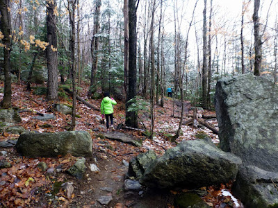
A nice coating of snow in the woods
The trail mostly traverses across the mountain with minimal elevation change
Cobble Ledge, also known as Cobble Lookout, is supposedly named for the old quarry near the start of the hike, which provided some of the rock for the construction of the Whiteface Memorial Highway, but it could just as easily be named for all of the loose cobble rock covering the ledges. The views from the ledge take in Wilmington and the Ausable Valley more than a thousand feet below, and Giant, Hurricane and Jay Mountains in the distance. Directly across from the ledge are Whiteface, Esther and Marble Mountain. Looking closely at Marble Mountain you can pick out the former lift line and some of the old trails from the former Marble Mountain ski area. The old ski lodge building is now the atmospheric research center. A fascinating history of the Marble Mountain ski area can be found here and also in local author Jeremy Davis’ book Lost Ski Areas of the Northern Adirondacks.
Looking out towards Wilmington, the Jay Range and Hurricane Mountain
The former ski lodge. Marble Mountain is the ridge beyond the building.
Clouds obscured our view of the upper elevations of Whiteface and Esther, and although there were some flashes of blue between the clouds, the sky never cleared off. Snow coating the upper elevations of Esther and Whiteface was a reminder that ski season is just around the corner.
If you go: From the four corners in Wilmington, follow Route 431 approximately 3 miles to the start of the Whiteface Memorial Highway. Bear right towards Franklin Falls on County Route 72 (also marked as Gillespie Drive). Proceed about a quarter mile to the trailhead on your right.


No comments:
Post a Comment